- What is GeoTagging?
- GeoTagging in Education blog (http://geotaggingineducation.blogspot.com)
- GeoImgr.com - "one-off geotagging" (sample picture here)
- GPS units, data loggers, and GPS-enabled cameras
- ArcGIS Explorer Online ("quasi-geotagging", example "Esri Conference Video Map")
- Microsoft Pro Photo Tools (PC-only)
- ArcGIS Explorer (add-in: Image Geotagger)
Showing posts with label iPhone. Show all posts
Showing posts with label iPhone. Show all posts
Tuesday, September 14, 2010
Resources for NCGE Live Webinar (#ncge)
Resources for today's NCGE live webinar:
Wednesday, June 30, 2010
GeoTagging Resources for #ISTE10
Below you will find the sample data pack for the noon BYOL GeoTagging workshop at ISTE '10.
Updated: Download data pack [200K zip file]
Download Google Picasa [Windows | Mac | Linux]
Other resources referenced:
Updated: Download data pack [200K zip file]
Download Google Picasa [Windows | Mac | Linux]
Other resources referenced:
- http://geoimgr.com
- Microsoft Pro Photo Tools 2 (Windows-only)
- GPSPhotoLinker (Mac-only)
- ArcGIS Explorer (Windows-only)
Monday, June 28, 2010
GeoTagging Twitter Text with iPhone & GPSTwit (#ISTE10)
Last Fall, Twitter began adding support for geolocating Twitter posts (Tweets). This is an opt-in feature of Twitter, that you must enable. To enable this feature, log in to Twitter and select "Settings" in upper right corner. Under the "Account" tab, check the box for " ". This will allow Twitter.com (image 1 - note the toolbar at top requesting to use my location) or third party apps to distribute your location with each Tweet. More details, privacy info, and an F.A.Q about "geotagging" Twitter posts is available from Twitter.

 One easy-to-use iPhone app for posting geotagged Tweets to Twitter (including photos) is GPSTwit (not to be confused with GPSTweet whch Tweets your position only). At $.99, this little app allows you take a photo, include a Tweet, optionally geotag, and post a Tweet to Twitter. The image is displayed on GPSTwit.com, along with other images. Recently I posted a picture of downtown Denver during the ISTE 2010 conference (#ISTE10).
It's fast, simple and works great for geotagging text or text+pic.

It's fast, simple and works great for geotagging text or text+pic.
Sunday, June 27, 2010
GeoTagging Made Simple with iPhoto '09
If you're like most Mac users, you probably already have a large number of photos in iPhoto. Hopefully, you're using iPhoto '09 (retail price: $0 with new Macs; $79 US upgrade) because no prior version has the built-in support for geolocating your pics.
To geotag an individual photo:
From Apple.com:
"Places allows you to search and sort photos by location, using data from any GPS-enabled camera or iPhone. Don’t have a GPS-enabled camera or iPhone? You can still use Places by adding your own location information: Just start typing and iPhoto instantly gives you a list of locations to choose from. Want to add places to lots of photos? Select an Event, an album, or a group of photos shot in the same place, and iPhoto can add your location information to all of them at once."

To geotag an individual photo:
- Click the small “i” icon in the bottom right corner of your photo (image 1). This will flip your picture over.
- Click on the words “photo place” and then on “find on map”.
- You can now put in the location of your picture either by adding the street address, city and state/country, latitude and longitude, or certain well-known locations by name (e.g. St. Louis Zoo).
- Click “Assign to Photo” when you have found the correct location.
- You can also add a description of the photo by clicking on the “description” word and typing into the box. You can rename your photo here as well by clicking on the name .
- Congratulations! You have just “geotagged” your photo! All your information should now show up. You can zoom in and out on the map, as well as switch between “Terrain”, “Satellite”, and “Hybrid” views.

Thursday, March 25, 2010
Using the iPhone to Collect Data for GIS
Charlie Fitzpatrick of the ESRI Education Team, recently posted a great blog on, as you might guess, collecting location data with the iPhone and displaying it in ArcGIS Explorer.
"Like most iPhone users, I delight in picking up "new" uses for it. When away from home, I use my phone's built-in GPS to track my morning run and get me back safely. Last week, I rode the train from DC to Philadelphia to exhibit at a conference for science teachers. As I sat down on the train, I decided to follow our progress."
Read more at the ESRI Education Community Blog
Friday, March 19, 2010
Geotagging at the National Conference on Science Ed - NSTA 2010 Philly

Taking a bit of advice from this very blog, I decided to geotag my trip to the 2010 National Conference on Science Education in Philadelphia, PA. To help me keep up with it all, Anita Palmer also contributed several images
I'm using an iPhone and PixelPipe and occasionally, a Nikon P6000 (with built-in GPS) to record my images and post to Google's Picasa Web Albums. The iPhone can use either its GPS or cellular triangulation. As many of these photos are being taken indoors, it seems that most of the positioning info is coming from the cellular triangulation. I seem to keep "clumps" of pictures that are pretty close, but not spot-on. As a result, I'm tweaking the position of many of these pictures, using Picasa Web Albums.
Since I'm geotagging and posting these images in (mostly) real time, each time you visit the gallery you should see new pics. Granted, the conference itself may not provide a wealth of geography across which my pictures can post, but hopefully I'll see a few sites while in Philly and add those to the map as well.
If you would like to contribute to this gallery, email your geotagged photos to: trbaker.nsta2010@picasaweb.com by Sunday, March 21 (6pm EDT). Include your name and description.
Thursday, March 18, 2010
Geocaching with an iPhone
Do you or your students carry iPhones or iTouches? Probably, since the word on the street is that 25% or more of the country's middle school kids carry one. If you are an avid geocacher, or still a muggle but interested in learning, read on to learn about this fun, outdoor activity!
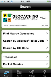 Geocaching is a high-tech scavenger hunt that uses coordinates to navigate to a hidden treasure, or geocache. Before iPhones, a geocacher needed to purchase a GPS receiver in order to geocache. Now, you can download one of many apps to your iPhone and go on your first hunt. There area couple geocaching apps out there, but I like the Geocaching App from Groundspeak. The app does cost a few dollars, but it's a lot less than buying an expensive GPS. Once you have downloaded the app and registered on geocaching.com for your free membership, you are ready to go!
You will then choose from the list which geocache you want to find, and a page with all the "specs" for that cache will come up. It will tell you how far the cache is, and give a description and hints to finding the cache. When you are ready to find your treasure, just hit "Navigate to Cache" and a map like the one below will come up.
 Geocaching is a high-tech scavenger hunt that uses coordinates to navigate to a hidden treasure, or geocache. Before iPhones, a geocacher needed to purchase a GPS receiver in order to geocache. Now, you can download one of many apps to your iPhone and go on your first hunt. There area couple geocaching apps out there, but I like the Geocaching App from Groundspeak. The app does cost a few dollars, but it's a lot less than buying an expensive GPS. Once you have downloaded the app and registered on geocaching.com for your free membership, you are ready to go!
The app itself is self-explanatory. In order to find nearby caches, you will have to allow it to use your current location. This is how I find most of my caches--I just go to a park and tell my app to "Find Nearby Geocaches" and up comes a list of all the caches, from the closest on out.
You will then choose from the list which geocache you want to find, and a page with all the "specs" for that cache will come up. It will tell you how far the cache is, and give a description and hints to finding the cache. When you are ready to find your treasure, just hit "Navigate to Cache" and a map like the one below will come up.
The balloon is the cache while the blue dot is you and the line of arrows is the path you will take to find the cache. If you hit the road button underneath the "View Compass" button, you can choose the type of map you prefer to use. 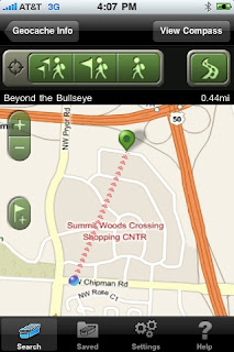
This app is nice because it connects directly to the geocaching.com website, meaning you will have access to thousands of caches all over the world. You can add specific caches to your favorites list, make field notes while caching, and look up a hint if you are having trouble finding a cache. There's even a compass setting to help you get your bearings if you are caching in an unfamiliar place. All in all, a very useful tool for a very fun activity. Happy Geocaching!!
Wednesday, March 17, 2010
GeoTagging with your own iPhone:Using PixelPipe
 Editorial Note: Pixel Pipe no longer transmits the location of the image at the time it was taken but rather the location at the time the image was transmitted. Pixel Pipe can still be a useful tool for students, if that can transmit the images immediately after taking them. (06/23/2010)
If you are a lone geotagger with an iPhone, you have many options (iPhone apps) for publishing your pics to the web.
I've experimented with a few photo-sharing applications, but I seem to keep coming back to PixelPipe, a service and an application for publishing pictures to a number of photo-sharing websites. PixelPipe's website boasts, "Publish photos, video, audio, text and files on over 100 online destinations and counting...". It is impressive! PixelPipe can run on Apple iPhones, Google Androids, Palm Pres, and several others. They've also created photo-sharing apps (or plug-ins) for: Firefox, Picasa, Google Talk and more.
.jpg)
This is a great way for the solo geotagger to make quick work of publishing images to a photo-sharing website that supports geotagged images, like Flickr or Picasa Web Albums. You can even tie PixelPipe to your Twitter account to automatically tweet about your newly uploaded pics.
The screenshots above are from PixelPipe running on an iPhone 3GS (publishing to Picasa Web Albums). Enjoy!
Tuesday, March 16, 2010
GeoTagging with student iPhones and Picasa Web Album
Why an iPhone?
Apple iPhones have gained rapid and dramatic market share in consumer mobile devices. This trend may be the most evident among kids and young adults. My own informal polling of students, teachers, and principals leads me to suspect that anywhere from 25% to 50% of middle schools students are carrying one of these devices. While many of these students have pages of apps and the Apple data plan, few of them can buy an app. For teachers, this means that potentially 50% of students in your class are carrying their own data collecting device that will geotag images. Students can email the geotagged images directly from the iPhone to Picasa Web Albums, after making a few tweaks in Picasa.

Setting up your classroom Picasa Web Album
- If you don't already have a Google account your use for the classroom, create one.
- Login to your classroom account and head to Picasa Web Albums
- Click on "Settings" in the upper-right corner.
- On the "General" tab, check the box next to "Upload photos by email" and note the special email address you're given. after entering a secret word (usually an @picasaweb.com address).
- Now, when your students take a geotagged photo, they just email it to this address.
- These emailed photos will appear in a "Drop Box" folder and will need to be moved to another public folding of your choice.
.jpg)
Steps for classroom activities
- Students use the built-in iPhone camera app to take a geotagged photo.
- Students share the photo by emailing it to the address, provided by Picasa.
- You (teachers) will need to move the photos to a new album.
- Students can then comment on their photos, contributing any other attribute information collected during the study.
What a great way to empower students, engaging them with their tools and tech, while extending classroom and collaborative data collection! Share your thoughts or experience below.
Subscribe to:
Posts (Atom)