Showing posts with label Geocaching. Show all posts

Friday, February 11, 2011

Finding Needles in Haystacks: Learning from patterns in GPS data

Finding Needles in Haystacks: Learning from patterns in GPS data
by Roger Palmer, GISetc & Tom Baker, Esri
at TCEA 2011 in Austin, TX

GPS gets your students out into local environments and interacting with the world. See how simple it is to integrate geocaching, EarthCaching, and data collection into your classroom.

Download the Session Presentation [PDF]. 

Tuesday, November 16, 2010

chirp! for geocaching

We haven't seen a product like this before and since it's targeted to geocachers, thought we'd share it: a wireless geocaching beacon.  At the very least, it could serve as an "intelligent" geocache, perhaps at its best, it could better allow those with low vision to have a better geocaching experience.

from the Garmin website:

chirp is a one-of-a-kind wireless beacon designed specifically for the outdoor adventures of geocaching. Affordable, durable and waterproof, chirp can communicate with, and be programmed by, any compatible wireless-enabled Garmin handheld (sold separately). chirp stores hints, multicache coordinates, counts visitors and confirms the cache is nearby. chirp is password protected and has a battery life of up to one year.

Get & Store Hints

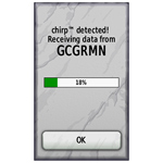
chirp detection screen (on an Oregon)
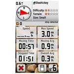
Trip computer screen showing chirp detection indication on dashboard (on an Oregon)
chirp can be programmed by any compatible wireless-enabled Garmin handheld to store geocaching hints and other information. When other geocachers arrive near your cache, they’ll be alerted that the cache is nearby, and then they’ll be able to access the hints you’ve loaded into chirp. And when you return, chirp will tell you how many visitors have been to your cache.

Monday, June 21, 2010

GIS for Geocaching

If you geocache with students or youth group members, take a look at a new one-page flier "7 Ways To Use GIS for Geocaching".  A GIS, or Geographic Information System, is a powerful digital mapping tool that for the geocacher can allow for the exploration or discovery of new caches.  For those managing a geocaching course or even just a large number of caches, a GIS can also help.

For students and youth, a GIS like ArcGIS Explorer desktop can be used to create a multimedia maps that serves as a "report out" the geocaching adventure.

If you have suggestions for enhancing the flier, please let us know.

As an aside, If you need a set of GPS receivers to use for a school or club project, consider the GSA's GPS loaner program operated by GISetc.   The loaners are free but shipping and insurance must be covered.


    Thursday, March 18, 2010

    Geocaching with an iPhone

    Do you or your students carry iPhones or iTouches? Probably, since the word on the street is that 25% or more of the country's middle school kids carry one. If you are an avid geocacher, or still a muggle but interested in learning, read on to learn about this fun, outdoor activity!

    Geocaching is a high-tech scavenger hunt that uses coordinates to navigate to a hidden treasure, or geocache. Before iPhones, a geocacher needed to purchase a GPS receiver in order to geocache. Now, you can download one of many apps to your iPhone and go on your first hunt. There area couple geocaching apps out there, but I like the Geocaching App from Groundspeak. The app does cost a few dollars, but it's a lot less than buying an expensive GPS. Once you have downloaded the app and registered on geocaching.com for your free membership, you are ready to go!

    The app itself is self-explanatory. In order to find nearby caches, you will have to allow it to use your current location. This is how I find most of my caches--I just go to a park and tell my app to "Find Nearby Geocaches" and up comes a list of all the caches, from the closest on out.

    You will then choose from the list which geocache you want to find, and a page with all the "specs" for that cache will come up. It will tell you how far the cache is, and give a description and hints to finding the cache. When you are ready to find your treasure, just hit "Navigate to Cache" and a map like the one below will come up.
    The balloon is the cache while the blue dot is you and the line of arrows is the path you will take to find the cache. If you hit the road button underneath the "View Compass" button, you can choose the type of map you prefer to use.
    This app is nice because it connects directly to the geocaching.com website, meaning you will have access to thousands of caches all over the world. You can add specific caches to your favorites list, make field notes while caching, and look up a hint if you are having trouble finding a cache. There's even a compass setting to help you get your bearings if you are caching in an unfamiliar place. All in all, a very useful tool for a very fun activity. Happy Geocaching!!