- What is GeoTagging?
- GeoTagging in Education blog (http://geotaggingineducation.blogspot.com)
- GeoImgr.com - "one-off geotagging" (sample picture here)
- GPS units, data loggers, and GPS-enabled cameras
- ArcGIS Explorer Online ("quasi-geotagging", example "Esri Conference Video Map")
- Microsoft Pro Photo Tools (PC-only)
- ArcGIS Explorer (add-in: Image Geotagger)
Tuesday, September 14, 2010
Resources for NCGE Live Webinar (#ncge)
Resources for today's NCGE live webinar:
Wednesday, September 8, 2010
NCGE Live Webinar: GeoTagging Media
Please join NCGE for our next live webinar on Tuesday September 14, 2010.
Webinar: GeoTagging Media
Date: September 14, 2010, 11AM Central
Description: This webinar is an introduction to geotagging digital photos and other media using ArcGIS Explorer Online, ArcGIS Explorer Desktop, and other free tools. GeoTagging is the process of assigning geographic information to digital media for mapping and visualization purposes. GeoTagging is great for class field trips, outdoor field experiences, storytelling, and travel.
Presenter: Dr Tom Baker, Esri Education Manager
Visit http://ncge.org for more information.
Webinar: GeoTagging Media
Date: September 14, 2010, 11AM Central
Description: This webinar is an introduction to geotagging digital photos and other media using ArcGIS Explorer Online, ArcGIS Explorer Desktop, and other free tools. GeoTagging is the process of assigning geographic information to digital media for mapping and visualization purposes. GeoTagging is great for class field trips, outdoor field experiences, storytelling, and travel.
Presenter: Dr Tom Baker, Esri Education Manager
Visit http://ncge.org for more information.
Saturday, July 10, 2010
GeoTagging at ESRI Education User Conference
This Saturday, July 10th kicks off the 10th annual ESRI Education User Conference with user presentations, computer labs, and plenty of special events. One of the computer labs is "GeoTagging Media and Incorporating Multimedia into ArcMap" to be held 1:30-2:45 Saturday.
The session will focus on ArcGIS Explorer and supporting web and desktop technologies. Software for geotagging will include
If you are attending the conference, the lab is "first-come, first-serve". Grab you seat early! It will fill.
The session will focus on ArcGIS Explorer and supporting web and desktop technologies. Software for geotagging will include
- Microsoft Pro Photo Tools
- ArcGIS Explorer (plus add-ins)
- Flickr: http://www.flickr.com
- GeoImgr: http://www.geoimgr.com
- ArcGIS Online via ArcGIS.com
If you are attending the conference, the lab is "first-come, first-serve". Grab you seat early! It will fill.
Wednesday, June 30, 2010
GeoTagging Resources for #ISTE10
Below you will find the sample data pack for the noon BYOL GeoTagging workshop at ISTE '10.
Updated: Download data pack [200K zip file]
Download Google Picasa [Windows | Mac | Linux]
Other resources referenced:
Updated: Download data pack [200K zip file]
Download Google Picasa [Windows | Mac | Linux]
Other resources referenced:
- http://geoimgr.com
- Microsoft Pro Photo Tools 2 (Windows-only)
- GPSPhotoLinker (Mac-only)
- ArcGIS Explorer (Windows-only)
Monday, June 28, 2010
GeoTagging Twitter Text with iPhone & GPSTwit (#ISTE10)
Last Fall, Twitter began adding support for geolocating Twitter posts (Tweets). This is an opt-in feature of Twitter, that you must enable. To enable this feature, log in to Twitter and select "Settings" in upper right corner. Under the "Account" tab, check the box for " ". This will allow Twitter.com (image 1 - note the toolbar at top requesting to use my location) or third party apps to distribute your location with each Tweet. More details, privacy info, and an F.A.Q about "geotagging" Twitter posts is available from Twitter.

 One easy-to-use iPhone app for posting geotagged Tweets to Twitter (including photos) is GPSTwit (not to be confused with GPSTweet whch Tweets your position only). At $.99, this little app allows you take a photo, include a Tweet, optionally geotag, and post a Tweet to Twitter. The image is displayed on GPSTwit.com, along with other images. Recently I posted a picture of downtown Denver during the ISTE 2010 conference (#ISTE10).
It's fast, simple and works great for geotagging text or text+pic.

It's fast, simple and works great for geotagging text or text+pic.
Sunday, June 27, 2010
GeoTagging Made Simple with iPhoto '09
If you're like most Mac users, you probably already have a large number of photos in iPhoto. Hopefully, you're using iPhoto '09 (retail price: $0 with new Macs; $79 US upgrade) because no prior version has the built-in support for geolocating your pics.
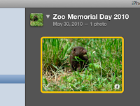
To geotag an individual photo:
From Apple.com:
"Places allows you to search and sort photos by location, using data from any GPS-enabled camera or iPhone. Don’t have a GPS-enabled camera or iPhone? You can still use Places by adding your own location information: Just start typing and iPhoto instantly gives you a list of locations to choose from. Want to add places to lots of photos? Select an Event, an album, or a group of photos shot in the same place, and iPhoto can add your location information to all of them at once."

To geotag an individual photo:
- Click the small “i” icon in the bottom right corner of your photo (image 1). This will flip your picture over.
- Click on the words “photo place” and then on “find on map”.
- You can now put in the location of your picture either by adding the street address, city and state/country, latitude and longitude, or certain well-known locations by name (e.g. St. Louis Zoo).
- Click “Assign to Photo” when you have found the correct location.
- You can also add a description of the photo by clicking on the “description” word and typing into the box. You can rename your photo here as well by clicking on the name .
- Congratulations! You have just “geotagged” your photo! All your information should now show up. You can zoom in and out on the map, as well as switch between “Terrain”, “Satellite”, and “Hybrid” views.

Monday, June 21, 2010
GIS for Geocaching
If you geocache with students or youth group members, take a look at a new one-page flier "7 Ways To Use GIS for Geocaching". A GIS, or Geographic Information System, is a powerful digital mapping tool that for the geocacher can allow for the exploration or discovery of new caches. For those managing a geocaching course or even just a large number of caches, a GIS can also help.
For students and youth, a GIS like ArcGIS Explorer desktop can be used to create a multimedia maps that serves as a "report out" the geocaching adventure.
If you have suggestions for enhancing the flier, please let us know.
For students and youth, a GIS like ArcGIS Explorer desktop can be used to create a multimedia maps that serves as a "report out" the geocaching adventure.
If you have suggestions for enhancing the flier, please let us know.
As an aside, If you need a set of GPS receivers to use for a school or club project, consider the GSA's GPS loaner program operated by GISetc. The loaners are free but shipping and insurance must be covered.
Wednesday, June 16, 2010
Geotagged Images in ArcGIS Explorer with GeoRSS

If you have already created a gallery of geotagged images in one of the many photo sharing websites (e.g. Flickr, Picasa Web), you can easily ingest a feed (or data stream) of you photos with the geography intact. This feed is in the form of a GeoRSS file and is created each time it is called by ArcGIS Explorer - meaning your images are always up to date. The power in this approach is that you can select images from different galleries and different websites, displayed against a variety of base maps and other geography. You can see my ArcGIS Explorer GeoRSS Photo map at ArcGIS.com.

To create your ArcGIS Explorer GeoRSS photo map
- For Flickr users, scroll to the bottom of your Photostream page and find the "geoFeed" link. You'll want to copy this URL and use it in ArcGIS Explorer. Be sure you have relevant location sharing options turned on.
- For Picasa Web Albums users, select a gallery, select an Album and find the "RSS" link. You'll need to copy this URL and use it later in ArcGIS Explorer. Note that you must have created an "Album Map" in order for the RSS feed to contain geographic data.
- Open ArcGIS Explorer and press "Add Content". Select "GIS Services".
- Press "New Server Connection".
- Change Server Type to "GeoRSS" and paste your geoFeed or RSS URL from Flickr or Picasa Web Albums.
- If you receive an error, the first and most likely problem is that all proper location sharing options in Flickr or Picasa Web Albums are not enabled. Revisit and try again.
Lastly, if you want to share your ArcGIS Explorer file, save your work as an .nmf (file) and upload to ArcGIS.com. The accounts are free and take only a second to set up.
Saturday, May 29, 2010
Upcoming ISTE Denver BYOL: GeoTagging: An Introduction to Spatially Enabling Your Digital Media
At ISTE 2010 in Denver, discover Geotagging! Geotag digital images and video to place your media on the map! Great for enhancing field trips, outdoor data collection, travel, and special events.
More info and sign-up.
By the conclusion of this BYOL session, participants will be able to add, edit, or delete geotag (geographical) information to digital images and video (as EXIF data or in sidecar files). Participants will geotag using at least three different software tools. Participants will create visualizations of their media using webmapping tools (such as Google Maps) and Digital Globes (such as ArcGIS Explorer or Google Earth). Participants will actively identify and group report-out direct connections to their existing curriculum.
Significance: The concepts and techniques in this session are intended to be introductory in nature, using an often-familiar concept like digital imaging and extending it into the rapidly growing field of geotechnology. Geotechnologies (including GPS, Geographic Information Systems, Remote Sensing, and Image Processing) can readily extend science, social science, and education technology inquiry by providing a rich resource for asking and answering questions.
More info and sign-up.
Thursday, May 27, 2010
Upcoming workshop: GeoTagging Media and Incorporating Multimedia into ArcMap
Learn to use and create geotagged media to facilitate classroom inquiry! This hands-on workshop will explore several web and desktop tools for geotagging images and media. ArcGIS Explorer and other tools will be used to create maps and visualizations of the media. Optionally, bring some of your own JPG photos on a USB drive.
Attend the ESRI Education User Conference, July 10 - 13, 2010 in San Diego, CA. More info: workshop | conference.
Attend the ESRI Education User Conference, July 10 - 13, 2010 in San Diego, CA. More info: workshop | conference.
Subscribe to:
Posts (Atom)