Wednesday, February 9, 2011
Tuesday, November 16, 2010
chirp! for geocaching
We haven't seen a product like this before and since it's targeted to geocachers, thought we'd share it: a wireless geocaching beacon. At the very least, it could serve as an "intelligent" geocache, perhaps at its best, it could better allow those with low vision to have a better geocaching experience.
from the Garmin website:
chirp is a one-of-a-kind wireless beacon designed specifically for the outdoor adventures of geocaching. Affordable, durable and waterproof, chirp can communicate with, and be programmed by, any compatible wireless-enabled Garmin handheld (sold separately). chirp stores hints, multicache coordinates, counts visitors and confirms the cache is nearby. chirp is password protected and has a battery life of up to one year.
Get & Store Hints
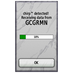 |  |
chirp detection screen (on an Oregon) | Trip computer screen showing chirp detection indication on dashboard (on an Oregon) |
chirp can be programmed by any compatible wireless-enabled Garmin handheld to store geocaching hints and other information. When other geocachers arrive near your cache, they’ll be alerted that the cache is nearby, and then they’ll be able to access the hints you’ve loaded into chirp. And when you return, chirp will tell you how many visitors have been to your cache.
Wednesday, November 10, 2010
CAST 2010: A Picture's Worth a 1000 Lessons
We'll be in Houston, TX for the Texas Science Teachers' Convention CAST! The presentation is Friday.
Code: WS2184
Today's cameras are truly tying more data together in rich and meaningful ways. When combined with GPS locations these tools can really be powerful data collection devices to do investigations. We will cover how to get your pictures position information, how to store this information, what to do with geotagged images once taken and finally how to best use them as class room tools in many different sciences. It won't even have to come out of your science budget!
Audience: Teacher / Pre-Service
Grade Level: Middle School
Content: Earth / Space Science / Life Science
Start Time: 4:30 PM - 5:30 PM
Scheduled Room: 362 AD
Updated 11/15/2010: Session PowerPoint now available for viewing or download via Google Docs.
Updated 11/15/2010: Session PowerPoint now available for viewing or download via Google Docs.
Thursday, September 30, 2010
Update to the Microsoft Pro Photo Tools download
If you find the Pro Photo Tools links not working navigate to Microsoft download site to download the latest version of Microsoft Pro Photo Tools. This may require a validation of a Microsoft product such as Internet Explorer.
Wednesday, September 29, 2010
Resources for #NCGE GeoTagging Workshop (Thurs, 8am)
Resources for NCGE workshop:
Download data pack [download 200K zip file]
Agenda:
Download data pack [download 200K zip file]
Agenda:
- What is GeoTagging?
- GeoTagging in Education blog (http://geotaggingineducation.blogspot.com)
- GeoImgr.com - "one-off geotagging" (sample picture here)
- GPS units, data loggers, and GPS-enabled cameras
- ArcGIS Explorer Online ("quasi-geotagging", example "Esri Conference Video Map")
- Microsoft Pro Photo Tools (PC-only) [download]
- ArcGIS Explorer (add-in: Image Geotagger)
Thursday, September 16, 2010
"GeoTagging Media" computer lab at NCGE Conference (#ncge)
Dr. Shannon White and Dr. Tom Baker will be conducting a "GeoTagging Media" computer lab session at the upcoming meeting of the NCGE in Savannah, GA, Thursday September 30. 8:00-8:45 AM.
Conference attendees will be charged $10 for attending this session. All proceeds to go to NCGE. Learn more about the Esri sponsored GIS lab at the Esri Education Community blog
Conference attendees will be charged $10 for attending this session. All proceeds to go to NCGE. Learn more about the Esri sponsored GIS lab at the Esri Education Community blog
Tuesday, September 14, 2010
GeoTagging Media Webinar Recording Now Available (#ncge)
NCGE Webinar Series – GeoTagging Media
Duration: 00:49:49
URL for Viewing: http://esri.acrobat.com/p76481044/
Summary: NCGE Webinar Series - GeoTagging
Language: English
Uploaded on: 09/14/2010 10:50 AM
Presenter: Dr. Tom Baker, Esri Education Manager & NCGE Executive Planning Board
For information about other NCGE webinars to join NCGE, visit http://www.ncge.org
Resources for NCGE Live Webinar (#ncge)
Resources for today's NCGE live webinar:
- What is GeoTagging?
- GeoTagging in Education blog (http://geotaggingineducation.blogspot.com)
- GeoImgr.com - "one-off geotagging" (sample picture here)
- GPS units, data loggers, and GPS-enabled cameras
- ArcGIS Explorer Online ("quasi-geotagging", example "Esri Conference Video Map")
- Microsoft Pro Photo Tools (PC-only)
- ArcGIS Explorer (add-in: Image Geotagger)
Wednesday, September 8, 2010
NCGE Live Webinar: GeoTagging Media
Please join NCGE for our next live webinar on Tuesday September 14, 2010.
Webinar: GeoTagging Media
Date: September 14, 2010, 11AM Central
Description: This webinar is an introduction to geotagging digital photos and other media using ArcGIS Explorer Online, ArcGIS Explorer Desktop, and other free tools. GeoTagging is the process of assigning geographic information to digital media for mapping and visualization purposes. GeoTagging is great for class field trips, outdoor field experiences, storytelling, and travel.
Presenter: Dr Tom Baker, Esri Education Manager
Visit http://ncge.org for more information.
Saturday, July 10, 2010
GeoTagging at ESRI Education User Conference
This Saturday, July 10th kicks off the 10th annual ESRI Education User Conference with user presentations, computer labs, and plenty of special events. One of the computer labs is "GeoTagging Media and Incorporating Multimedia into ArcMap" to be held 1:30-2:45 Saturday.
The session will focus on ArcGIS Explorer and supporting web and desktop technologies. Software for geotagging will include
If you are attending the conference, the lab is "first-come, first-serve". Grab you seat early! It will fill.
The session will focus on ArcGIS Explorer and supporting web and desktop technologies. Software for geotagging will include
- Microsoft Pro Photo Tools
- ArcGIS Explorer (plus add-ins)
- Flickr: http://www.flickr.com
- GeoImgr: http://www.geoimgr.com
- ArcGIS Online via ArcGIS.com
If you are attending the conference, the lab is "first-come, first-serve". Grab you seat early! It will fill.
Subscribe to:
Comments (Atom)